

william.scherk
-
Posts
9,165 -
Joined
-
Days Won
66
2 Followers


About william.scherk
- Birthday 01/24/1958
Recent Profile Visitors


william.scherk's Achievements
")


Single Status Update
See all updates by william.scherk
-
Measurement Omission round one
Graphic plotting of location data
Plats, cadastral maps, land survey systems
Consider addresses on a mile grid.
Avenues run east-west
Streets run north-south.
Start a address numbering system
The corner of 0 Avenue and 0 Street
On 0 Avenue, addresses increase by increments
The first block of Zero Avenue addresses runs from 1 up to 100.
"You are here" on the 0-100 block of Zero Avenue.
Now go ten miles north and twenty miles east
Now select a good corner property.
Record the address
Record the intersection of X Street and X Avenue.
Record a precise latitude and longitude of the corner.
Spell it out:5998 264 St49.110817, -122.492586
-

I had to look Lulu Island up on Wikipedia. I am still trying to figure out the rest. Peter
Lulu Island is the name of the largest island in the estuary of the Fraser River, located south of Vancouver, British Columbia, and the second-most populous island in British Columbia, after Vancouver Island. The city of Richmond occupies most of the island, while a small section at the eastern tip, known as Queensborough, is part of the city of New Westminster.
Lulu Island is situated between the two principal arms of the Fraser River estuary across and downstream from the City of New Westminster. The Middle Arm of the Fraser River separates it on the northwest from Sea Island, the site of Vancouver International Airport, which, despite its name, is also part of the City of Richmond. At the western edge of the island lies Sturgeon Bank, a large sandbank which falls off into the Strait of Georgia on its western edge.
-

Peter wrote:
QuoteI had to look Lulu Island up on Wikipedia. I am still trying to figure out the rest. Peter
I missed this earlier (which is the nice part of OL 'Status' posts, they just just drip down the main page unnoticed for the most part).
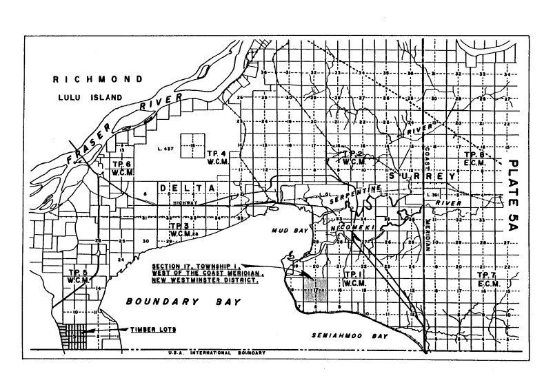
I was having a bit of a brainstorm, Peter, so I don't expect anyone to follow the suggested steps -- I am still puzzling over how to present a useful argument using Grid Coordinates. I am trying to use mapping and address conventions as a way to think about how earthquake swarms can appear to be all going off at the exact same points (in two dimensional/left-right+top-bottom) as the grid pattern that set off the thread.There are many conventions of mapping that use a kind of grid coordinate system. Most of these are familiar to Americans of the Great Plains, and to Canadians of the Prairie provinces. They are known as Homestead Survey Systems or Township sytems. A brief bit from a history of Surrey BC says it better than I can:
QuoteThe basis of this was the township; a block six miles by six miles containing 36 sections. Each section was one mile by one mile and contained 640 acres. Each section in turn was divided into quarter sections each containing 160 acres. It was the quarter section parcels that were available for Surrey Homesteaders to preempt. The land could be held as a homestead as long as it was improved. The lines dividing the sections became the grid pattern for Surrey's arterial road system.
Zooming ahead, the homestead grid in Surrey had no numbers until after 1957. Before that all roads had names, no numbers, and with post-war suburban growth, the lack of a rational address system was getting in the way of mail, fire, and other emergency services. ("We got a fire out here on Jonston's Farm off Hjorth Road in Happy Valley").
Here's a very simplified depiction of what resulted:
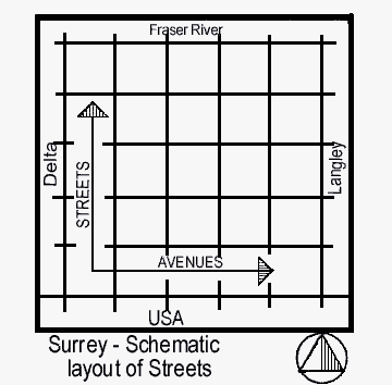
So, starting out west in Delta is a mythical Zero Street. At the USA/Canadian border another street, actually called Zero Avenue. This pattern extends all the way to the last of the flatlands on the south of the Fraser River -- almost all the way to Hope, BC.
So, it is possible to have two adjoining properties with long addresses, something like this:
- 8090-8121 210 Street [lat/long: 49.149526, -122.639881]
- 21098-21000 80B Avenue [lat/long: 49.149248, -122.639483]
Link to such a corner (Google Maps).
Anyway, this is not a finished thought. It will continue to drip down the All Activities page until I get to the central point!
-
Bonfire symbols as markers on a township-scale map -- a way to record and display individual "happenings" to the limits of precision!
Within a six mile by six mile grid, plot a hundred or so "bonfires" in a random pattern.
Record the individual events with Google Maps "My Maps" or Acme Mapper session markers. Keep a list of each event as a latitude/longitute position.
...
-
